
[ad_1]
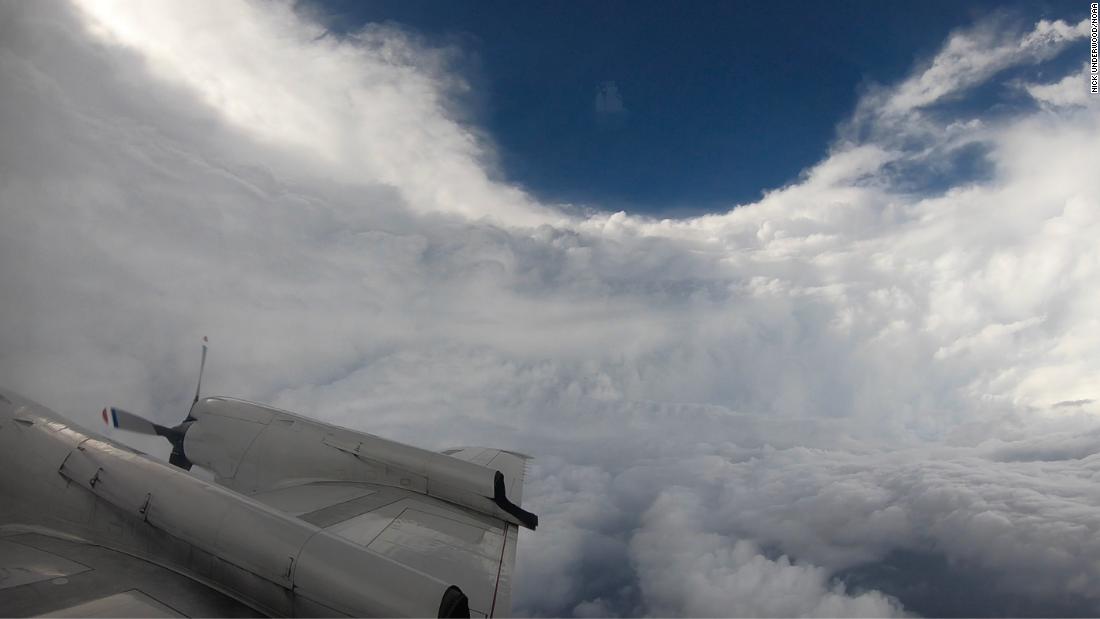
“Three, two, one, let go of the probe,” he heard the flight director say.
“Probe away,” Underwood replied, as he released a dropsonde data collection device from the plane.
After 20 to 30 seconds, he knew the release was a success, as data about the storm streamed into his computer.
Data on temperature, pressure, humidity, wind speed and direction began to arrive from the probe. Then, seconds later, the instrument splashed into the ocean.
It is this information that is sent to the National Hurricane Center, which then informs the rest of the world that Elsa is still a tropical storm, on its way to impact the United States.
This was Underwood’s first mission of the 2021 hurricane season, but he’s not a rookie. As one of the National Oceanic and Atmospheric Administration’s hurricane chasers, he has a front-row seat to some of the world’s fiercest storms.
“Flying through a hurricane is a lot like being on a wooden roller coaster in an automatic car wash,” Underwood said.
“There is a lot of vibration, a lot of movement from left to right, but there is also wind and rain and graupel and everything else hitting the windows as you fly through the rain bands and through. the wall of the eyes as you make your way through, ”he said.
Being a hurricane chaser is not for the faint hearted. They are carrying out eight-hour missions in and around the storm and will continue to do so daily for six days until the threat is over.
“I’ve been through some of the biggest storms in the last couple of years. It’s always exciting and something that I love to do and something that is important to so many people so I take it as seriously as I can. “said Underwood.
He made it through Hurricane Irma in 2017. It was his first flight as a crew member, which happened to be a Category 5 hurricane.
“We deployed to Barbados and did a few missions while Irma was still forming over the Atlantic,” Underwood said.
“Then Irma made her way to a Category 5 storm and here I am – I worked for over a year, but it was my first major storm as an official team member. . very good, ”he said.
Underwood said being in the eye of the storm during Hurricane Matthew in 2016 is what really got him hooked.
“It was my first flight in a hurricane and I was an observer. I was not 100% prepared for what I was about to experience,” he said.
“The first two hours I was fine and the next six I got really sick and wasn’t having the best time, but I remember once the sun came up and we were still doing passes in the eye of the storm and I remember looking up out the window being sick and thinking, wow! It’s amazing. “
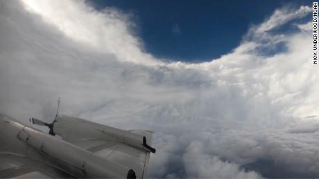
“Once you’re in the eye, that’s where the real chase begins,” Underwood said.
“We’re maneuvering to find where our flight level winds go down to zero, because that’s where the real center of pressure is.”
As the crew come out of the eye, they hit the eye wall, which is the strongest part of the storm.
“It’s called a wall for a reason. You go from a beautiful sunny day to one of the worst times you can be in,” he said.
Surprisingly, he said, it’s some of the smaller storms that rock you more than the bigger ones. The planes have 12 to 15 people on board. They all have specific roles and make the process work transparently.
“The flight director is constantly looking at the radars we have on board and trying to choose the best parts of the hurricane to go through. The parts that are not absolutely going to shake us,” he said.
Underwood also flew over Hurricanes Dorian, Harvey and even Maria, shortly before making landfall in Puerto Rico. It was a poignant moment for him as he was on the plane looking at the data and realizing on the spot that this storm was going to strike directly.
“I remember with Maria this really heavyweight because you look at the data and hope it turns out somewhere and we realize that just wasn’t going to happen and of course Puerto Rico was devastated.”
“Every storm is different and you certainly respect them as such,” he said. “All we can do is put the information together and use it to better alert people to what lies ahead.”
Underwood doesn’t take his job lightly. He knows that the better he and the crew will fare in the storm, the more accurate the forecasts will be and the better warned people will be of what to expect.
Seen from space
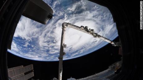
As Tropical Storm Elsa swept across the Caribbean Sea, NASA astronaut Megan McArthur shared this image taken from her vantage point aboard the International Space Station.
She wrote: “Tropical Storm Elsa from @Space_Station today. Stay safe everyone.”
Weather in brief
Parts of New York City and New Jersey were at a standstill Thursday afternoon as 2-4 inches of rain fell in a short time and flooded streets, subway stations and entire neighborhoods.
This happened just before Tropical Storm Elsa swept through the area and brought in more rain.
Cities like New York and Boston could see 1 to 4 inches of rain.
Tropical weather outlook
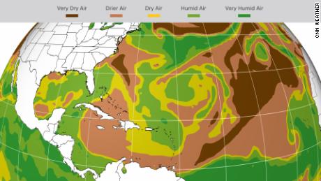
The tropics are expected to remain very calm this week. No tropical activity is expected for the next five days, according to the National Hurricane Center.
“There are a few areas like the Gulf of Mexico and around the Caribbean islands that are favorable for development, but most areas experience strong windshear or dry air,” CNN meteorologist Dave Hennen said. .
“None of our reliable computer models are showing any development this week.”
This dry air will reduce the chances of development. Of course, the forecast can always change, so make sure you stay up to date throughout the week.
Hurricane season typically peaks around September 10 and ends on November 30.
Weekly weather number
130
Extreme heat continues in the west

Death Valley has now recorded a high temperature of 128 degrees or more for three consecutive days (Friday – 130, Saturday – 129, Sunday – 128).
“The only other longest streak dates back to six days in July 1913. Death Valley has the option of extending the current streak to four consecutive days on Monday,” CNN meteorologist Haley Brink said.
Seven locations beat or equaled their all-time high temperature records on Saturday: Winslow and Phantom Ranch, Arizona; Saint-Georges, Utah; Las Vegas; Mercury, Nevada and Barstow and Bishop both in California.
St. George hit 117 degrees on Saturday, equaling Utah’s all-time high temperature record, if verified.
“Even higher elevations like Lake Tahoe have reached 90 degrees, setting records,” said the hens.
While the heat isn’t as extreme as we’ve seen over the weekend, temperatures will still be 10 degrees above average for places like the interior of the Pacific Northwest and the Great Basin. . Nighttime lows were also extremely hot during this long-lasting heat wave, according to the Weather Prediction Center.
Lows in parts of the southwestern desert did not fall below 90 degrees, making it more difficult for the human body to overcome the effects of heat stress.
“Localized relief from extreme heat can come in the form of monsoon showers and storms every day in parts of Arizona and New Mexico,” the Prediction Center said.
[ad_2]
Source link